Wednesday, May 16, 2018:
We never got dinner last night due to the storm. We just stayed on the boat. In the morning, Jane did a bunch of laundry while I finished with the last blog post. It was drizzly, but we decided to go to the zoo anyway. We hopped the free Southwest Shuttle and got off at the Metro stop. Two short train trips and we were close enough to walk on to the zoo. It was free. We got to see most of it, but did not get to see the new baby gorilla.

It is a great zoo, but in the midafternoon the hunger pangs were setting in. We walked back to the Metro station and found a nearby Chipotle. That fit the bill. The Metro ride back was crowded and we lost our way coming out of the subway. We had to walk around the block to find the stop for the shuttle bus. We got back around 4:30 to the boat and did some planning since we are going to leave tomorrow even though the weather looks crappy. It is set in for a number of days and we don’t know when we’re going to get any good cruising weather. I laid out some stops for the next 8 or 9 days with marinas and anchorages and including a stop in Annapolis for the Blue Angels show. We know we will have to be flexible with the schedule since travel totally depends on the weather. Karen from Free Spirit, who we met in the club, came by with hand written list of her favorite Chesapeake Bay stops moving north from the Potomac. It was a sweet thing to do and we appreciated having some experienced input. Since we didn’t get to go out Tuesday night, we set out for a late dinner at Masala Art. It is an Indian restaurant, tonight with an excellent musical duo that we did not expect. Everything was totally superb! I never knew you could fix okra like that!
Thursday, May 17, 2018:
We got word that our daughter, Meredith, who is on a trip to London arrived safely and I asked her to give my best to the Queen. She will get to see the royal wedding processional/motorcade from a sidewalk pub.
While Jane went up to the CVS to see if they carried Almond Milk, I checked out the engine and filled the water tanks. Jane also had to stop in the office and turn in my key card and confess about hers falling out of her pocket on our bike ride to Georgetown. The marina agreement calls for a $100 charge for lost key cards, but after she got the final bill, it was only $25.
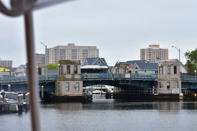
Unassisted, we slipped off the dock at 1105 in a slight drizzle and I eased out of the Washington Channel no wake zone very slowly because 1) It is a no wake zone, 2) The police boat was lurking in the next marina, and 3) the high tide was over the sea wall on the west side of the channel and any wake would have been destructive to the golf course. By 1230 we were by Mount Vernon, but making good time and decided that we’d come back another time on a day that is not so slimy. At 1345 we passed the inbound Looper boat Serenade heading upriver. He called us on the VHF and we warned each other about the abundant floating debris in the water. I had been dodging logs and trash the whole way. I don’t know why there is so much trash in this river. At 1545 we anchored in Aquia Creek in five feet of water on 70 feet of rode. It is rainy, but the winds are light and the water glassy. Later, Jane whipped up the most incredible dinner. She made Veggie Fritters with garbanzo bean flour. Topping the fritters was a yummy vegan ranch chipotle dressing. I made sure she could duplicate this by writing it down. It was totally awesome! After dinner, I cleaned up and she read. I got in some practice on my old guitar and she says I’m getting better. Not good, just better.
Friday, May 18, 2018:
We awoke with the boat covered in midges. Like large mosquitos that don’t bite or sting, but when they hatch, they are everywhere. They were all over the outside of the boat and they leave green poop stains.

When I say they were all over the outside of the boat, I mean really all over. I think from a distance our boat would have looked gray. When I went up top to get ready, the back of the fly bridge enclosure was black with what must have been a million bugs. They swarmed all over and around me as I got close to go through. I went back down and told Jane to just stay inside. I knew she wouldn’t do well with this. Now I know why some folks call these bugs Sons o’ Midges. What a huge mess. At 0845 it was raining and foggy, but my phone based radar showed that it would be breaking soon. Our forecast was for ENE wind of 7 to 11 mph with showers and a chance of thunderstorms after 1400 and seas around one foot. That doesn’t seem too bad and I thought that if we stayed here would we have twice as many midges tomorrow. Maybe if we get moving the breeze will blow them away. At 0945 the rain stopped so I cranked up the motor. We got the anchor up at 1000. At 1005 it started raining again, but I figured it will be over soon. Jane stayed in the saloon while I drove from the bridge. We communicated by cell phone (once I had my ringer turned on). That would help. I was alone on the fly bridge with about 5000 midges inside the enclosure. One got in my eye, another in my mouth and yet another up my nose. I opened up the front windows and the back flap and tried blowing them out with the leaf blower. (OK. Now I see why Jane wanted to buy that thing.) That helped some especially with the brisk wind coming from the east. The ride became somewhat uncomfortable between Maryland Point and Mathias Point, but not unbearable and the rain should be letting up soon. It finally did stop and I got us close to the left descending bank where the river turns south after Mathias Point so we’d be out of the wind. Jane came up and tried her best to get rid of the bugs. She brought the dust buster and also used the blower. She did not like it. After we went under the Harry Nice Memorial Bridge, I tried a couple of times to raise the Dahlgren Range Patrol on the radio. They never answered so I had to assume that the range is not “hot” today. I decided to take the detour they had me traverse on the way upriver so we could stay more in the lee of the shore. It is a short cut anyway compared to the main channel. The winds started to increase and shifted from ENE to SE and after Swan Point we were taking it on the nose. The fetch extended all the down to the mouth of the Potomac and across the Chesapeake. It resulted in some choppy seas with a short duration between waves. The ride was too rough to continue and Jane let me know it with that look of fear or was it misery mixed with hate in her eyes. I handed her my phone to look up the nearest point of relief using the electronic chart app. We needed a protected anchorage and we needed it quickly. She couldn’t do it so we switched places and I found one just up the Wicomico River at Bushwood Wharf Cove. We switched places again and I stepped on her foot. It was not a good time for that. I heard a loud scream and then another. This, I am beginning to recognize as pain and expression of terror. There were tears and white knuckles and then silence and white knuckles. The forecast one foot seas were now four or more and I’m getting it from both weather and wife. Thank goodness it was only five miles to the anchorage at Bushwood and once we rounded the point at Cobb Island the motoring was tolerable. We anchored at 1437 in 13 feet with ample rode out given the conditions.


We worked together trying to clean up the damn bugs, but knew we’d only be able to do so much. I got out the high pressure water gun and hooked it up to the stern hose. That did some good, but when we get to a marina, we will need to do a major clean-up. Later, inside, Jane’s foot seems to be ok and she is cooking vegetable curry and is talking to me. Barely. The wind is hooting and vibrating the window screens to the point of a humming sound. It’s a real wind instrument.
Saturday, May 19, 2018:
We got an early text from Meredith in England that she’s got a primo spot to watch the Royal Wedding on a big screen in a pub and the processional will pass right by. It is still raining on our anchorage spot in the Wicomoco River. I reviewed the weather. It was raining and there was a small craft advisory, so we just stayed put even though we’re getting rocked a bit. After breakfast we tried to do some more cleaning up of the Midges outside. We took off the screens and cleaned them and the windows. It was pretty nasty and my sweetie was grossed out. We took advantage of the idle time to finish up the work on our taxes and got it all ready to send to our CPA. In the late afternoon it was just rainy and stormy. We just have to wait out Mother Nature. We played a spirited game of gin rummy after dinner and Jane won the prize of 20 minutes of back massage. Yeah, right. Back massage. So we both won.
Sunday, May 20, 2018:
It was an awful night on the hook. The boat would bob several times bow into the wind and then swing one way and get rocked side to side. Then it would swing back, bob a few more times when the bow was into the wind and then swing to the other side and get rocked from that direction. Neither one of us slept worth a darn, but the anchor did not slip one iota. We got up at 0715 and it was still overcast but not so dark. The rain had stopped. After swearing night before last that we will never venture out in small craft warnings again, we decide to pull anchor and move on (in small craft warnings). The winds are out of the WSW at 11 to 13 with gusts to 16. Waves are forecast for 1 to 2 feet, we think we can get to St. Mary’s. We changed plans a couple of times and elected on taking a slip at Dennis Point Marina on Carthagena Creek. The anchor was up at 0840 and I got the mud washed off. At 0928 we find waves in the Potomac of less than one foot and at 1000 the sun broke through and by 1030 we had rounded Rugged Point. At 1210 we docked at the Dennis Point Marina and Campground. It is a pretty nice place in a remote location and the channel coming is pretty crooked and tight. I remarked that a tight channel leads to a snug harbor. It was very snug.


They have a pool, and are trying to get it opened for the season by the coming weekend (Memorial Day). But they do have a little restaurant and it looks like it will suffice. Jane did laundry and showered while I detailed the boat removing all evidence of the Sons ‘o Midges. I spent two hours on the fly bridge alone and Jane advised me to quit at 1600 and go get a shower. The offerings in the restaurant were typical bar type foods, and I splurged on a crab cake sandwich and onion rings. We were glad to have our feet on terra firma and enjoyed the evening.
Monday, May 21, 2018:
We dropped lines at 1000 for the approximate 40 mile trip to Solomons Island. A favorable forecast was showing winds from the east at 5 to 10 and waves to one foot. Jane found us a marina there that boasts all the amenities for only a dollar per foot. By 1100 we were back in a smooth Potomac under sunny skies. At 1120 we passed Lookout Point and though the waves were rougher it wasn’t too bad. At 1220 we were coming by the Point No Point Light in excellent conditions – no waves and glassy waters. We were nearing another Navy firing range and I kept well away from it. Regardless, soon their patrol boat hailed us to move in closer to the shoreline. I willingly obliged. We docked at the Calvert Marina with the help of Sammy the dockhand. We immediately ran into Lorrie and Roger from Reality and met their friends Steve and Anna who have a 49’ DeFever, Journey. We borrowed the marina’s loaner car, an old vintage Mercedes. The girl in the office said it is old so don’t take it over the bridge. Dang, we couldn’t get to Walmart, but got to the Wie Market that was adequate (but no Publix) and the wine store. When we got back, another boat had arrived to the dock. It was in the style of lobster boat. They were flying the gold AGLCA burgee so we knew they had already gone around at least once. We introduced ourselves to George and Caroline of the Lydia E whose home port is Venice, Fla. When we heard him talk we knew he wasn’t from Florida and we learned that George was a retired lobsterman from Maine. So the bunch of us, George and Caroline, Jane and I and Steve and Anna all assembled at 1730 for docktails aboard Reality before traipsing over to the Hidden Harbor Restaurant. Later we watched the space station flyover from the fantail of Journey.
Tuesday, May 22, 2018:
The weather wasn’t begging us to move on so we stayed another day at Calvert. Jane did some laundry and cleaning. I changed the water filter and finally finished painting the generator pan and few spots that needed touching up in the engine room. It was cloudy most of the day and may have been ok for travel, but I was fine staying put. We lowered the dink into the water and took a ride around the several creeks and the harbor. There are a number of marinas here and we saw several Loopers. We went by some very pretty waterfront houses. Steve and Anna had left as did George and Caroline. We met Robert and Cheryl when they docked across from us in their boat Michigan Girl. He’s a retired fire chief from San Bernandino, but she’s originally from Michigan, hence the name. So we had Robert and Cheryl and Roger and Lorrie for happy hour in our boat. We all stayed in the saloon to enjoy the air conditioning. Everyone retired to their respective vessels for dinner and the storm rolled in.
Wednesday, May 23. 2018:
We refilled the water tanks and cranked up at 0805 and moved out to the fuel dock. We took on 200 gallons of diesel at 2.95 per gallon. At 0841 we were on our way to Annapolis. The weatherman promised us northwest winds of 5 to 10 miles per hour and seas of one foot. Isolated showers in the afternoon were also in the forecast. At 0945 we passed the liquid petroleum structure.


It is joined to the shore by a tunnel. At noon, in the middle of the Chesapeake, we experienced glassy flat water, but as we approached Annapolis, the chop got very rough. There must have been at least 2500 boats in the harbor for the Blue Angels show.
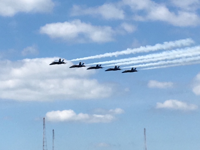
They put on quite a show and as the boats cleared out many demonstrated that they have a lack of respect for their fellow boaters. It was a mass exodus but we were able to pick our way through and find a mooring ball in the main field. Jane had trouble getting the mooring ball tied. Probably because I had not prepped the line for her. I was surprised that we found one on such a busy week. It is graduation week for the Naval Academy. I came down from the helm and we got it fastened.
When we looked up, there were Steve and Anna on Journey tied to the mooring ball right next to us.

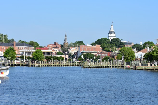
We spoke for a bit and then launched the dinghy to go walk about the town. Annapolis is a very cute town with loads and loads of history. The dinghy dock is at the dead-end of what they call Ego Alley.

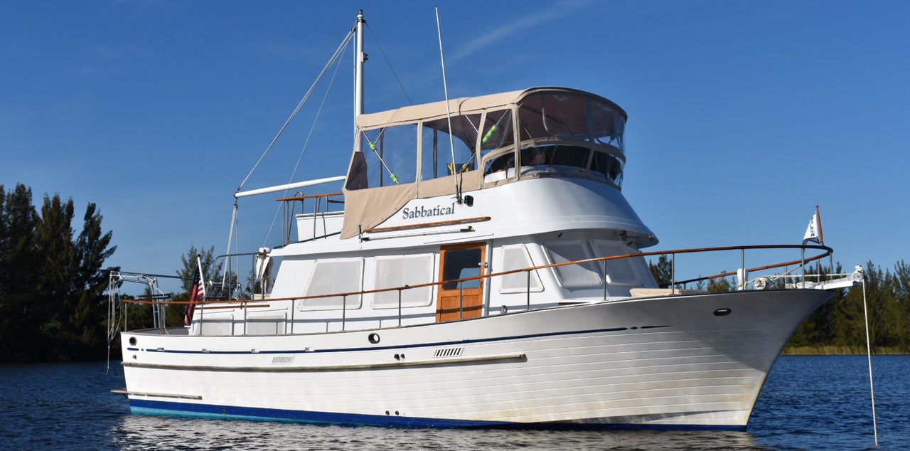
Ego Alley is the canal of water that Pusser’s Landing overlooks. Pusser’s has a very long dock-front and it was packed. It seems like all the boaters here must bring their boat into Ego Alley take it all the way to the end, make a pivot turn in the tiny basin and boat back out. Large boats, small boats and even sail boats under sail power do this seemingly without ceasing. We also took the dinghy around the harbor and up Spa Creek a little ways and then returned to Sabbatical to get cleaned up for dinner. When we were ready, Steve and Anna had us over to Journey for a drink and they versed us up on the best places to eat here. Sailboat racing is very big in Annapolis and on Wednesday afternoons they race out in the bay. As they come back into dock they make great sport of sailing right through the mooring ball field barely missing the boats there and entertaining those of us watching. It is a great show. We dined at Taco Vida on Anna’s suggestion and it was wonderful. We got word from Meredith that she had arrived safely back into the USA and it was a Happy Birthday for her.
Thursday, May 24, 2018:
Jane had found a guy that does free walking tours of the town and so off we went to meet at the appropriate spot. We found out later, that he only does it a few days a week, but when she called, he was very helpful and emailed us a list of places to see. We got on campus at the Naval Academy and walked over to watch their parade.
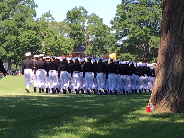
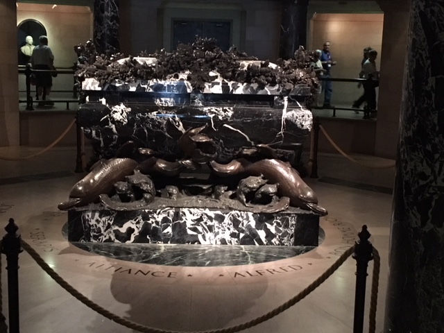
It is the end of the semester and they have a lot of tradition and ceremony. After the 4000 midshipmen were assembled on the parade grounds, I was glad we were standing in the back under the shade trees because we saw at least 20 midshipmen faint and had to be helped off. It appeared that this is not uncommon as they seemed to have Navy hospital corpsmen positioned behind each company to assist. After the parade, we visited the chapel which is beautiful and went down to John Paul Jones’s crypt.
If you’re ever in Annapolis, this is a “must see”. Then we walked all around the historical section, visited St. John’s College campus and went into the State House. It is the oldest continuously used State House in the nation. It has been lovingly preserved and it is very cool that they still use it for the Maryland state government. It was at one time the seat of government for the United States and I relished in wandering through the building and standing in the very room where George Washington resigned his commission and turned the army over to the representative government.
We stopped at Pusser’s for a “Painkiller” before heading back out to the boat.

Lorrie and Roger had received the part and repaired their engine, made the trip up from Solomons and were aboard Journey. We were invited aboard and pretty soon so were two other couples and it was ad hoc docktails on the fly. We retreated to our own boat and rested in the air conditioning and napped for a while. Later, we dinghy’d back into town and walked about 15 minutes to Metropolitan Kitchen for one of the best and most economical dinners we’ve had so far. We had three delicious appetizers all at half price. That filled us up and we hiked back to the dink.
Friday, May 25, 2018:
The forecast showed a south wind of 7 to 10 kts in morning changing to 10 to 13 in the afternoon with seas of one to two feet so at 0842 Jane released us from the mooring ball and I eased us twixt the resting vessels in the glassy calm of the crowded field. The river out of the basin was much different from when we came in. Where there were several thousand before, now, there were only a few boats. It was a little rolly in the bay, but we had a crystal blue sky with not a cloud in sight.

At 0930 we were under the Bay Bridge, but only making only six miles per hour against the tide. We had been making for Havre De Grace, but Jane found us a spot just off the channel in the Bohemia River. She found Brewer Bohemia Vista Marina for only a dollar fifty a foot and they have a pool. The day was warming up and cool pool would feel pretty good.
By 1355 we were passing the Sassafras River and entered the Bohemia River at 1515. The wind had picked up but by 1530 we were docked in a slip and I got kudos on the boat handling from Christie, the marina owner and her dockhand. I helped Jane get a load of laundry started and we hung out in the pool with the locals that keep their boats there on a seasonal basis. Later, for dinner, we had a pizza delivered right to the boat.
Saturday, May 26, 2018:
I had studied the flows in the C & D (Chesapeake and Delaware) Canal and figured if we left around 0900 we’d have a helping current all the way through. We shoved off at 0905 with Jane not feeling well. At 0940, even though I had been paying attention, we hit a submerged log. I backed off immediately as soon as I felt the contact and put it in neutral. The log popped up behind the boat and a little to starboard. It was about the size of a fence corner post. It was a glancing blow and Jane’s quick check below revealed no damage. At 0956 we entered the C & D Canal. We didn’t have any reservations, but before we passed Chesapeake City, I had contacted the Delaware City Marina and made arrangement for a couple of nights on their along-side dock. The Delaware City Marina is located on a canal that runs from the Delaware River back to the C & D, but due to depth and a low bridge we had to go out into the Delaware and come back in from that end. By 1055 we passed the Conrail Lift Bridge and by 1147 were passing under the Reedy Point Fixed Bridge. We got out of the canal and entered the Delaware River turning upstream for about a mile to enter the Delaware City Canal. As arranged, we called on the radio to confirm docking instructions and were warned about some shoaling and the swift current flow, and told to prepare for a starboard side tie. At 1223 we pulled into the assigned spot with a starboard tie with the help of two young, but capable dock hands. We had no more than got the lines fastened when they announced that they would now spin us about by hand and we needed to prep for a port-side tie. I was somewhat miffed that they couldn’t let us know about that from the start so we could have all the lines and fenders ready, but we got it done and the result was that it would make leaving a lot easier.

One thing they do at DCM is give a weather briefing every day at 1700 in the marina store. We met other Loopers there and Tim, the marina owner briefed us on using the Delaware Bay Operational Forecast System website to get currents and wind forecasts. It is the best forecast system I have encountered and his demonstration was very well done. It gave me confidence that we could make a very good decision on when to leave to traverse the river and bay. At the lower end of the bay we would be entering the Cape May Canal and staying at Cape May. It would be a full day’s run from Delaware City to Cape May.
We met Tim and Tricia King on the dock before the briefing and afterwards the four of us walked down to Crabby Dick’s for dinner. Crabby Dick is famous for his balls. Crab balls that is, but they are served with a side of seaman sauce. That should give you an idea of the entire motif of this place. Tim and Tricia spoke of needing to buy a pair of headset walkie-talkies and we had purchased a pair, but never used them. After dinner we headed back to our boat and got them out for Tim and Tricia try. It was just what they needed since their boat does not have a fly bridge and they can’t hear each other when docking.

Then we joined them aboard their boat, Patricia Anne, and we celebrated the sale with a glass of wine. It had been a bad weather day with rain on and off and thunderstorms on the way. Back aboard Sabbatical, we checked the DBOFS site and confirmed that Sunday would not be a day to make it to Cape May so we made a plan to walk to a local church.
Sunday, May 27, 2018:
We walked over to the Ebenezer United Methodist Church. There were only 16 total people there and that included us, the worship leader, the organist, and the lady who stood in for the preacher and delivered the sermon. We met everyone there and they asked us to talk about our trip. This church is over 100 years old and I hope they can find a way to get some young families in there. It was raining when we came out and a couple gave us a ride back to the marina. It was rainy and drizzly all day. Jane did some laundry and the two of us returned to Crabby Dick’s to redeem our coupon for the free crab balls, then we strolled on down Clinton Avenue to their sister restaurant, Lewinsky’s on Clinton. This guy has a real funky sense of humor. Lewinsky’s is a little more upscale, but not much. The food was incredible though and we enjoyed fried cauliflower and avocado hummus.

Monday, May 28, 2018:
Having checked the latest update at 0500 and deemed the currents and winds to be favorable, I released us from the dock unassisted and eased us out the narrow canal at 0610. Bear and Patricia Anne had left just before six. The forecast showed winds from the northeast at five to ten miles per hour with waves of two feet or less. That should make for good conditions. However, in the afternoon the winds were to turn from the southeast and there was a slight chance of showers. By 0700 we were past Reedy Island and at 0925 we passed the Ship John Shoal light.
We kept well to the side of the channel to avoid the container ship, Gluecksburg inbound at 0956. We also passed a tanker and a dredge and the inbound Dole Columbia.


By 1130 we made the Miah Maul Shoal light and at noon we were running at 9 to 10 mph, well above our still-water standard. Fears of the dreaded Delaware Bay had been replaced with a memory of a fine day cruising and we entered the Cape May Canal at 1320. At 1345 we docked on a T-head at the South Jersey Marina and immediately saw Captain Terry of Magic. There were a number of Looper boats there in the marina and other nearby marinas. Docktails was being organized for later, but we needed to get to the store, so we took our folding grocery cart and humped it about a mile to the Acme Grocery Store. I’m sure this must be where Wiley Coyote shops. We loaded up our cart and dragged it back to the boat. Cape May is a very cute little beach and boating town with lots and lots of old Victorian homes and many vacation rentals. By the time we got back and showered, Docktails was in full swing on the patio with eight other couples.

There was lively discussion about which way to go leaving Cape May. Most were favoring to go out the inlet and run up the beach to Atlantic City. I knew it was going to be foggy, so we were choosing to stay on the back side of the barrier island and go up the New Jersey Intracoastal Waterway. After Docktails broke up, we went with three other couples over to the Lobster House for dinner. The Lobster House in Cape May is huge and a very well run operation.
It was packed being Memorial Day, but the service and food were both top notch. We would like to stay longer in Cape May, but want to take advantage of the weather in the morning and get closer to NYC. South Jersey is a very nice marina with the best restrooms and showers we have found thus far.
Tuesday, May 29, 2018:
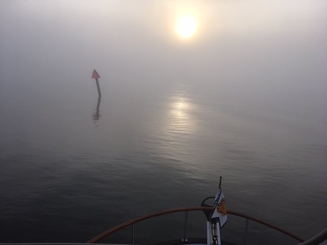
We left the dock at 0615. It was foggy, but we could see across the marina, so I was ok with that much visibility knowing that it should lift once the sun got up some. It was still low light and as I eased out of the marina by the Lobster House, the fog was thick. I mean pea soup thick. I wasn’t sure I could see 50 feet. I started blowing the horn and kept the throttle at low idle. If we didn’t have GPS, we would have been stuck right there. But we could see on the screen where to go, we just couldn’t see where we were going. A shrimp boat emerged out of the mist in front of us like a ghost ship creeping along from our right to left. He had not been blowing his horn and he could probable see us on his radar. It was spooky and I was nervous. We got around him without incident. The crew on deck was as silent as the fog. They disappeared as I eased by their stern. Maybe it wasn’t even real. We kept on at idle speed with a keen watch. I had Jane fetch the fog bell and had her ring it every two minutes. As we made our way up the NJICW and past where the other boats were heading out the inlet, I had some measure of relief knowing that other marine traffic would be minimal. I was on edge and Jane was stressed by the fog, but by 0700 we were in Jarvis Bay and the fog was starting to lift.
Not so for the boats that took the outside route. I could hear them talking on the radio about other boats that they were spotting, especially one sailboat that seemed to pass very close and did not respond to their radio calls. We followed the reds and greens very closely so as not to get out of the channel as it winds through the shallow bays and creeks. We were feeling pretty good about our decision to take the inside route. Besides the winding of the waterway, we had to contend with New Jersey fishermen. Apparently, they only fish in the middle of narrow waterways and only a few will move to let another vessel get by. I began to be unconcerned about putting out a wake where normally, I slow way down for fishermen in small boats. By 0730 the fog was gone for us, but the boats in the ocean were still having to deal with it. It was slow going for us with lots of “No Wake” zones,

but we got through Peck Bay, Great Egg Harbor Bay and reached the Dorset Avenue Bridge in Atlantic City at 1235.
We requested an opening, and the bridge tender obliged and began to sound the alarm and put down the barricades. Directly, the barricades went back up. What was going on? After a few minutes, I radioed him again to ask and he said he had to abort the opening because a fire truck would be coming through. After 20 minutes, he got clearance to open and we never saw any fire engine, but got past his bridge and continued to wind around through the maze of canals. We spotted a family of geese crossing the waterway and Jane stood up to take a picture.
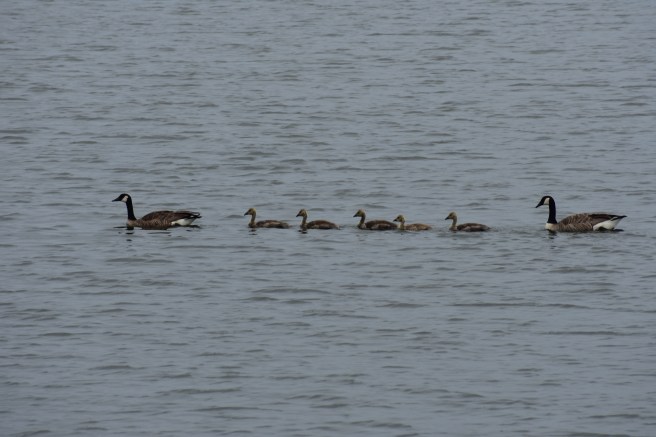
That was all it took for me to lose concentration on the navigational beacons. Damn squirrels. When I realized I was about to go on the wrong side of a green marker and was correcting, I spotted a red buoy and another green buoy beyond the green marker. Those must be new channel markers, I thought. So once I got correctly around the green marker, I headed for the green buoy. I split the two buoys and made for the red marker number 206 in the waterway. I was almost to it when we found the bottom with the keel. I thought I could perhaps just power on through it as I realized that the channel was just ahead. No going that way and there was no going in reverse at that point either. The low tide for Atlantic City was 1438 and it was 1320 when we ran aground. We have Boat US (think AAA for the water) so we put in a call. At 1340 we heard from Gary the Tow Boat operator and he said it would take him 45 minutes to get on scene due to all the no wake zones. I knew by that time we wouldn’t have enough water under the boat for him to pull it off. There was nothing we could do but sit and wait so we pulled out our novels and read. When Gary showed up, he confirmed that there was nothing he could do for us until the tide changed because we were too hard aground at that point. He went to get something to eat and we returned to reading while Sabbatical continued to lean further and further to port as the tide continued to drop. Jane was concerned that we might fall over so I told her we’d be ok as long as we stayed on the starboard side of the boat.
Gary returned at 1545 as promised and we made fast his heavy bridle to our stern cleats. He was pulling hard and trying to blow the mud out from under our boat with his powerful outboards.

We didn’t seem to be moving, so after a bit, I slipped Sabbatical into reverse to give some assistance and we could feel the movement begin. By 1627 we were underway again with no damage to the boat, but a bruised ego for me. The nearby railroad bridge was down and when we called the tender advised that we’d have to wait for two trains to pass first. I’m sure that he had been watching us through the entire fiasco, so I told him I’d try to wait in the deep water. Politely, he did not transmit his laughter over the radio. We made it through the Atlantic City maze without further incident and at 1750 we anchored in front of the Coast Guard station in nine feet of water on 120’ rode and decided that we’d just stay right there for another day.


We spent Wednesday reorganizing and relocating food and stuff to get ready for Travis, Rachel and the twins that will be on board once we get to NYC. We tried to figure out the best place to dock there and made reservations at Liberty Landing, but found out that it is too far for them to come visit us easily. I was delighted that Jane was able to cancel the reservation without charge since they charge $5.00 per foot and base their rates on the overall length which in our case is 42 feet instead of 36 feet. It would have cost $224 per night to dock there including their electricity charge. Travis suggested a spot called Gateway Marina which is just east of Coney Island and much nearer their apartment in Brooklyn. They only charge $3.50 per foot. It was still a lot more than we’re used to paying, but cheap by NYC standards. I was able to do some engine room maintenance, adding oil and cleaning out the strainer. We grilled veggies on the deck and did some more route planning after dinner.
Thursday, May 31, 2018:
The Atlantic City high tide was 1004 and I knew from research that we’d want to ride the rising tide for at least the first twenty miles of the waterway. The forecast showed that we’d experience southeasterly winds around 10 knots with gusts to 20 in the morning. Also a chance of showers in the morning with a chance of thunderstorms in the afternoon was indicated along with a dense fog advisory until 1000 hours. I determined that we should leave between 0730 and 0800 so we pulled anchor and left at 0740. The NJICW is notoriously difficult to navigate and I couldn’t disagree. The fog was not bad at all and there were few boats on the water. Those that were, were fishing; right in the channel. By noon we were crossing Barnegat Bay and it was getting foggy in the distance, but we could make out each marker without a problem, but then it got thicker and we had to rely on the GPS route to help us find them. We progressed without a hitch and arrived in the Point Pleasant Canal at 1450 with a helpful flow and we were making 10 miles per hour at 1400 rpm. Jane was impressed with my planning. We exited the canal into the Manasquan River and turned to the east going down stream still being pushed by the formidable current. We checked in with Hoffman’s Marina for docking instructions and told the girl that we had just exited the canal and were coming downriver. She said for us to go past the railroad bridge to the third T-head and dock there. We did, but that turned out to be their fuel dock and the hands there said we needed to return back through the RR Bridge and dock on the third T-head there. Apparently, the girl we talked to doesn’t know where the canal is. I negotiated the narrow RR Bridge both with and against the swift waters without a problem and we got tied for the night right behind our Looper friends, Kevin and Sandy on Koastal Karma. Jane found the laundry (free) and we joined the couples from Wine Speed and Koastal Karma along with Captain Terry from Magic for docktails at the picnic table. A plan was laid out for us all to depart around 0615 to make the open ocean run to Sandy Hook. Jane and I joined Kevin and Sandy aboard Koastal Karma for dinner and we turned in at an appropriate hour given the long day (62 ½ miles) and the early departure tomorrow.

The jersey canal is notorious for grounding boats. I saw a few boats stuck in the mud. I came through clean with my flat bottom. I first encountered fog in the Delaware bay and then as I left Cape May. I went outside up to Atlantic City before going in to escape the grey curtain.
When you leave NY ride the tide up the Hudson. It is explained perfectly in Skipper Bobs books. Works great.
LikeLike